CONVEI: Collaborative Network for Valuing Earth Information
Evaluating how Earth observations can improve decision-making and benefit society
© ESA/NASA
The magnitude and pace of global change demands rapid assessment of the state of our planet and the life that thrives on it. As governments, business, and financial institutions are increasingly committing to goals for sustainable development, understanding how science can improve decisions and their impacts on the planet is imperative to meeting those commitments. That’s why WWF, NASA, and USGS have formed CONVEI—the Collaborative Network for Valuing Earth Information—to study the role of information in decision-making to improve both.
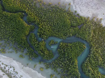
With the rapidly increasing development of satellite and other technologies, scientists are now able to gather increasingly sophisticated and detailed information about how the Earth’s physical, chemical, and biological (and many aspects of societal) systems behave. This information, called Earth Observations (EO), can provide real-time, globally available, and publicly accessible information for decision-makers to track current and future natural impacts and prioritize which actions to take for their localities. For example, conservation programs are using satellite data to evaluate program impacts on biodiversity, regulators are using airborne observations of methane emissions to identify point sources, land managers and emergency services are increasingly turning to EO-based wildfire forecasts to plan interventions and evacuations, and many other uses are proliferating. Importantly, EO can also democratize knowledge by providing people with direct access to powerful tools and information about the challenges their communities may face—knowledge that can be used to strengthen their influence and amplify their voice around decision-making in the places they live.

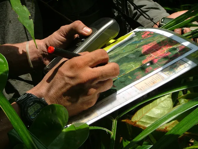
© Meg Gawler / WWF
While EO data can be used to create myriad beneficial outcomes, greater understanding of their direct value to lives and livelihoods remain. CONVEI is forming a transdisciplinary network of academic, public, and private sector scientists and practitioners to integrate Earth sciences, social sciences, and data sciences into their socioeconomic assessment approaches. Researchers in this growing network will assess how EO is currently used to benefit society, and how using it can change perceptions, behaviors, and decisions, as well as their resulting social, economic, and ecological outcomes. Ultimately, these insights can be used to build new understanding of the role that EO can play in decision-making and guide future technological development of EO toward greater utility.
What WWF is doing

© NOAA
WWF is already heavily involved in the translation of EO to delivering societal benefits, as a direct user of EO products in its conservation planning and impact monitoring, as an innovator of new EO applications to solve urgent sustainability problems, and as a convener of different audiences who care about planetary stewardship. As core providers of satellite data in the United States, NASA and USGS have long funded individual projects to support the development and use of EO; they are now looking for opportunities to scale beyond the individual project level, asking where EO has the greatest potential for rapid adoption and impact. WWF’s expertise, spanning engagement in international policy forums to working with local communities around the world puts us in the unique position to address these challenges.
Launching in 2023, over the next five years, CONVEI will be developing new ways of valuing EO and their contributions to society. Different evaluation methods and different types of values will be explored, drawing from economics, machine learning, behavioral psychology, cultural anthropology, and more. Applying these methods in real world decisions, CONVEI will evaluate the societal benefits of EO in contexts such as conservation, agriculture, water resources, disasters, and health. Along with highlighting the benefits of EO information, researchers will characterize the use of EO in complex decision-making processes, identify common barriers, gaps, and other challenges in the translation of EO to decision-relevant and actionable information, and make recommendations for improving the utility of and expanding the use EO in the future. A key piece of this evaluation will focus on how the decision-making process itself can transform through the use of EO, towards more transparent, and democratic deliberation. These evaluation projects will strengthen collaborations between Earth scientists, social scientists, and decision-makers, grow the community of practice for valuing EO, and communicate that value and its potential for improvement to policy-makers and funders investing in the advancement of EO. The insights gained through this new program of work on valuing EO will catalyze the next generation of satellite information to better support society’s most pressing decisions for people and the planet.
Do you use or produce EO in your work?
We are actively seeking collaborators to grow this network and provide opportunities to evaluate the impact of EO information, justifying further investment in your decision-relevant science and helping identify where new capacity is needed.
© WWF-Indonesia/Sunarto
Executive advisory committee
© Courtesy of Kate Brauman
Kate Brauman
© Courtesy of Kate Brauman
Global Water Security Center, University of Alabama
Kate Brauman is the Deputy Director at the Global Water Security Center at the University of Alabama. Brauman’s academic research includes assessment of water security based on worldwide trends in water consumption and availability, irrigation and agricultural water use, and the science and implementation of investments in watershed ecosystem services. She was a coordinating lead author for the 2019 Global Assessment of the Intergovernmental Platform on Biodiversity and Ecosystem Services (IPBES), a section lead for the 2021 UNEP Global Synthesis Report “Making Peace with Nature”, and a 2018 AAAS Leshner Leadership Fellow for Public Engagement. Prior to joining the Global Water Security Center, Brauman was a 2020-21 Water and Climate Resilience Fellow at the US Department of Defense through an AAAS Science Technology Policy Fellowship, where she worked on water resilience at military installations, and led the Global Water Initiative at the University of Minnesota’s Institute on the Environment. Brauman received her doctorate from Stanford University’s Emmett Interdisciplinary Program in Environment and Resources.

© Courtesy of Jiaying Zhao
Jiaying Zhao
© Courtesy of Jiaying Zhao
University of British Columbia
Jiaying Zhao is a professor of psychology and sustainability at the University of British Columbia, where she directs the Behavioral Sustainability Lab to design innovative behavioral solutions to tackle environmental and financial sustainability challenges like climate change and poverty. Zhao leads the work on encouraging collective climate action, recycling and composting, waste reduction, and biodiversity conservation. Moreover, Zhao develops cash transfer interventions to reduce homelessness and poverty. She has authored more than 100 articles and 140 invited presentations and received King Charles III Coronation Medal and Killam Research Prize. Zhao has a PhD in cognitive psychology from Princeton University. Zhao is also a faculty affiliate with the Center for Effective Global Action at University of California, Berkeley, and an invited researcher at J-PAL at Massachusetts Institute of Technology. She has advised dozens of governments, NGOs, and businesses, including the UN Sustainable Development Solutions Network, The US Social and Behavioral Sciences Team, The UK Commonwealth Secretariat, and the Privy Council Office of Canada.

© Courtesy of Yuta Masuda
Yuta Masuda
© Courtesy of Yuta Masuda
Paul G. Allen Family Foundation
Yuta Masuda is the Director of Science at the Paul G. Allen Family Foundation, where he advances strategy development, identification, and cultivation of science priorities in ocean health, terrestrial conservation, and climate change mitigation and adaptation for the foundation's Environment Program. Masuda serves on the boards of Oceans 5, the Shark Conservation Fund, the Volgenau Climate Initiative, and also serves as a member of the Food Systems Countdown Initiative and the Science Council for Conservation International. Prior to joining the foundation, Masuda was a Senior Sustainable Development and Behavioral Scientist at The Nature Conservancy. His work at the Conservancy examined how policies advancing conservation and sustainable development goals impact human well-being and environmental outcomes. He has published over fifty publications in outlets such as Nature Sustainability, Nature Communications, Global Environmental Change, Lancet Planetary Health, Environmental Research Letters, Conservation Letters, Land Use Policy, One Earth, and Frontiers in Ecology and the Environment. He holds a PhD in Public Policy and Management from the University of Washington and was a Peace Corps Volunteer in the Republic of Georgia.
© Courtesy of Renato Molina
Renato Molina
© Courtesy of Renato Molina
University of Miami
Renato Molina is an Assistant Professor in Environmental and Resource Economics at the University of Miami, where he studies the economics of natural resource management, climate resilience, and sustainability. He pursues interdisciplinary research on pricing the resilience of human and natural systems, while advising public and private stakeholders on conservation and adaptation strategies. Molina has published in both economic and interdisciplinary journals, and has received numerous awards, including an Early Career Research Fellowship from the Gulf Research Program of the National Academies, a Lindau Nobel Laureate Meetings Fellowship, and provost research funding at the University of Miami. Previously, he was a researcher at UC Santa Barbara’s Sustainable Fisheries Group and holds a PhD in Economics and a Master’s in Environmental Science and Management from UC Santa Barbara. Outside academia, he enjoys playing music, snowboarding, road cycling, and flying airplanes.

© WWF
Tadesse Wodajo
© WWF
National Oceanic and Atmospheric Administration (NOAA)
Tadesse Wodajo is an Economist with over 20 years of diverse experience in regulatory economics and economic valuation. He earned a Ph.D. in Applied Economics from Western Michigan University and has since held various roles in academia and federal service. Currently, Wodajo serves as a senior economist at the National Oceanic and Atmospheric Administration (NOAA), where, as part of a team of economists, he contributes to demonstrating NOAA’s value to society through robust social science analyses. Outside of work, Tadesse enjoys reading, painting, and traveling.
WWF team
© Kevin Arnold
Becky Chaplin-Kramer
© Kevin Arnold
Global Biodiversity Lead Scientist, Global Science , Director, CONVEI
Becky Chaplin-Kramer is the Director of CONVEI, where she leads the transdisciplinary network in its mission to uncover how Earth Observations and the information derived from them are used in decision-making and contribute to societal benefits. As Global Biodiversity Lead Scientist, Becky works across the WWF network and with external partners to advance the science and implementation of conservation strategies to support biodiversity and its myriad contributions to people's well-being.
Prior to WWF, Becky was a lead scientist for the Natural Capital Project (NatCap), a transdisciplinary partnership WWF co-founded with Stanford University, University of Minnesota, and The Nature Conservancy. In her work affiliated with both of NatCap's university partners, Becky led research on global ecosystem service assessment, linking earth observations and ecosystem service modeling, and accelerating the development of products and tools to integrate the values of nature into decision-making. Throughout her career, Becky has led ecosystem service assessments, scenario development and targeting exercises working with government, NGOs and companies around the world, from local to national to global scales. Her work has been published in top journals such as Science, Nature, and Proceedings of the National Academy of Sciences.
Becky was a Coordinating Lead Author on the Values Assessment for the Intergovernmental Science-Policy Platform on Biodiversity and Ecosystem Services (IPBES) and is now a Lead Author on the upcoming IPBES Nexus Assessment. She earned her PhD in Environmental Science, Policy and Management from University of California, Berkeley, and an MS and BS in Earth Systems from Stanford University.

© Keith Arnold
Sam Cheng
© Keith Arnold
Director of Conservation Evidence, Global Science, Learning and Evaluation Lead, CONVEI
Sam Cheng oversees CONVEI’s learning and evaluation components, ensuring that program activities deliver the initiative’s objectives and generate actionable insights. She leads the development of monitoring frameworks, tracks progress toward outcomes and supports adaptive learning and synthesis across the network. As the Director for Conservation Evidence in WWF she works across the organization and with external organizations to advance evidence-informed practice in conservation programs. She has extensive experience partnering with government agencies, conservation non-profits, multilateral institutions, and foundations to systematically evaluate the impact of conservation on ecological and social outcomes and identify key insights to guide policy, practice, and research. Her work also focuses on the process of utilizing evidence to inform decisions in conservation and development. She works with diverse partners to understand where, when, and how to provide timely and responsive evidence for different policy and program scenarios. Prior to joining WWF, Dr. Cheng was a scientist at the Center for Biodiversity and Conservation at the American Museum of Natural History where she was the lead for the first U.S.-based center with the global Collaboration for Environmental Evidence and the Research and Evidence Lead for USAID's Integrated Natural Resource Management Activity. She holds a PhD in Environmental Studies from the University of Colorado Boulder. Throughout her career, she has worked to develop and improve open-source methods and tools for identifying, synthesizing, and delivering evidence for pressing policy questions for conservation and development.
© Courtesy of Rich Sharp
Rich Sharp
© Courtesy of Rich Sharp
Remote Sensing and Ecoinformatics Lead, Global Science, Data science specialist and researcher, CONVEI
Rich Sharp serves as the Remote Sensing and Ecoinformatics Lead at WWF on the Global Science Team where he applies computational modeling, remote sensing technologies, and scientific computing to contribute to and further evidence-based conservation efforts. Rich leads CONVEI’s data management, processing, analysis, and interpretation activities. He utilizes machine learning/ AI techniques to extract insights from EO information and supports the execution and deployment of any additional pertinent algorithmic models for the program. Before joining WWF, Rich spent 10 years as the Lead Software Architect at the Natural Capital Project leading, and later supporting, the development of the InVEST Ecosystem Service software suite. During his tenure, Rich also supported NatCap scientists and the technical aspects of their projects, some by simulating global-scale physical and biophysical processes, and others with more traditional, but critical, general software support. He has co-authored dozens of peer-reviewed articles and presented on different topics ranging from the ecological impacts of cryptocurrency to the role of nonviolent action in advancing equitable environmental objectives. Rich earned his Ph.D. in Computer Science from The Ohio State University, specializing in computer graphics and numerical computing.
© WWF-US/Keith Arnold
Mabel Baez Schon
© WWF-US/Keith Arnold
Biodiversity Senior Specialist, Global Science, Program Manager, CONVEI
Mabel Baez Schon is the Biodiversity Senior Specialist on the Global Science team at WWF, where she leads research and programmatic efforts to advance conservation initiatives and the valuation of Earth science information. She is also the program manager for CONVEI. In her work, Mabel applies her expertise in ecology, geospatial science, and natural resource management to support global partnerships and field-based conservation programs. Her work includes designing and implementing methodologies for downscaling global datasets, conducting environmental assessments, and supporting policy-relevant science across WWF’s global network. Previously, Mabel served as a Natural Capital Postdoctoral Fellow at WWF, where she applied modeling tools like InVEST to evaluate the benefits of nature-based solutions. She has led or contributed to research and program delivery across Ethiopia, Costa Rica, Brazil, and Nicaragua. She earned her PhD in Forest Resources and Conservation from the University of Florida. Mabel is also trained in participatory facilitation and passionate about elevating local voices and cultural values in conservation planning.

© Courtesy of Cristina Mancilla
Cristina Mancilla
© Courtesy of Cristina Mancilla
Community Engagement and Capacity Development Specialist, Global Science, CONVEI
Cristina Mancilla (she/her) is a Specialist on the Global Science team at WWF, where she leads community engagement and capacity development for the Collaborative Network for Valuing Earth Information (CONVEI). Cristina manages the CONVEI Fellowship Program and programmatic strategy for community engagement. Prior to joining WWF, Cristina was the Community Engagement Officer at the National Center for Ecological Analysis and Synthesis (NCEAS), where she drew on asset-based community development and action research methodologies to foster reciprocal partnerships between scientists and local communities. Her work aims to enhance the social relevance and sustainability of environmental and ecological science by bridging the gap between scientific knowledge and community needs. Cristina’s research and practice focus spans across public engagement with science, small-scale fisheries, and equity-centered conservation in the U.S. and Mexico. Cristina holds a master’s degree in Environmental Science and Management from the University of California Santa Barbara and studied Biology and Environmental Studies at Williams College.